Aerial photos of the UK: The Millennium Map.
Use of aerial photos in planning applications.
Details of the Millennium Map of the UK are given on the getmapping website as follows:
"Since April 1999, when light and weather has allowed, four specially equipped aircraft have been flying at over 5,000ft, photographing every road, field and house. Over half a million miles later, the first ever seamless aerial photo of the country has been created, called the Millennium Map™. This is your chance to own a piece of this unique record, which is being constantly updated."
However, charges for prints are high - around Ł24 for an A3 print but at 1:4000 scale. This is too small to see details of individual properties clearly. Digital maps can also be purchased on-line.
All District Councils hold the digital mapped data for their area and are permitted to print up to four copies - at a cost of around Ł1 each for A4 size! Supply of .jpg files is unfortunately not permitted. However, the prints are adequate for supporting planning applications and similar purposes. A scale of 1:1000 or 1:1250 may be the best choice because this aligns with the scale of many site plans. Also, the aerial maps become fuzzy if any attempt is made to zoom in beyond 1:1000.
Aerial maps can be useful in assessing changes to land. An example follows.
In connection with the removal of trees from the Conservation Area of Sidford, the aerial photos of the Village End site at 1:1250 scale show a large tree close to the existing workshop building of Hamilton Garage and an extensive area of tree cover to the rear of the garden of Village End. All of these trees and shrubs have disappeared, as is described elsewhere.
|
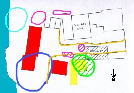
Superposition of tree cover (as deduced from aerial photographs) onto the site plan submitted with planning applications to extend Hamilton Garage, and build four new dwellings. A large tree (felled in 2003) is shown in green: the outline is the extent of the canopy and that clearly overhung the existing buildings. The yellow shading shows the proposed extensions. The nearby areas of vegetation and tree cover (shown purple) were also cleared in 2003 - they were in the way of the proposed access road. |
An area of mixed tree cover used to exist within the dark blue circle. The light blue circle is the approximate canopy area of a large beech tree near to the river bank - this is still standing. The proposed access road is edged brown. The proposed new dwellings are shown in red.
The proposed extensions to the industrial buildings were nodded through Sidmouth Town Council with little comment, despite that (if councillors had done their job properly and spoken to local residents) the felling of a large tree in the conservation area should have been raised. It is explained elsewhere that residents did not know of these plans until they had sailed through the planning committee of the Town Council. Both Hamilton Garage and Village End are in the conservation area of Sidford - as can be confirmed by using the EDDC website.
If the owner of the site succeeds with his planning application to build four houses on the site, he will have profited by up to Ł500,000. The applicant as shown on the planning applications is a Mr R Hooper of Hamilton Garage, Sidford. However, ownership of the land is more complicated. The whole story is reported on this website, starting here.